

A2Plus app for iPhone and iPad
A2+ is an application dedicated to the measurement of land area, perimeter and distance. The moderate grounds can be situated all over the world.
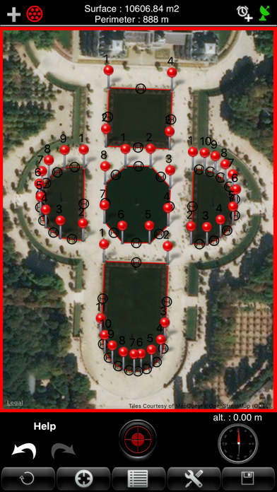
A2+ can measure and display the surface and the perimeter of several land on the same plan with intermediate distances. The measurement can be displayed in feet, Inch, Yard or Feet.
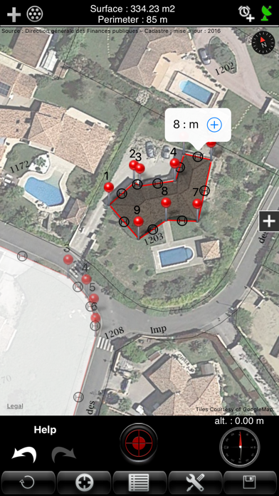
The application displays the French land registry superimposed on the map. Thus, the measurement accuracy of the plots is greatly improved (useful for a geometrician).
A2+ can save plans, edit them and export them via e-mail with the format "KML" (for use with software like Google Earth, Google Maps, World Wind, Sketchup ...) and "DXF" (AutoCAD).
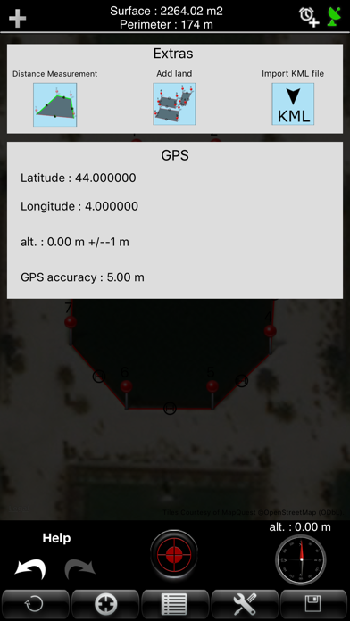
The application allows you to import KML files and view fully customizable and cumulative WMS layers.
Multilingual: English, French, German, Spanish, Italian, Portuguese, Japanese.
A2+ has 4 ways of functioning:
- GPS: The user is located on the field. He then confirms a succession of points describing at best the ground thanks to the position supplied by the GPS.
- GPS AUTO : The user is located on the field. The application automatically takes the points with a regular time interval.
Just move yourself along the ground so that its outline is drawn. The time interval is adjustable from 5 to 120 seconds. The automatic mode can be stopped and restarted at any time.
- Manual: the user seizes points manually without moving by finding a way on the map.
- Mixed: the user is on the ground and seizes points via the GPS, then can add it manually (for difficult access for example).
The calculation of the surface is effected and displayed at each input. The result can be stated in m2 square feet, square yard, are, ha.
Features :
- Automatic recording of points with a regular time interval.
- Measurement of several surfaces on the same plane.
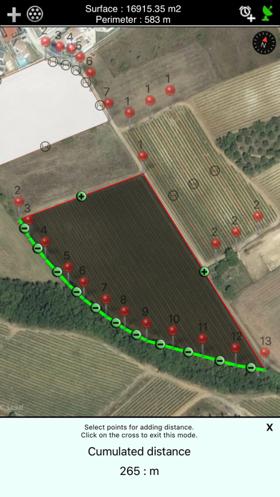
- Measure of cumulative distance.
- Viewing the perimeter and intermediate distances.
- Viewing a compass and altitude for better geolocation.
- Points Informations:
At any time, the user can know the seized coordinates of the seized points
- Movement of the seized points:
Every seized point can be moved with the finger to adjust its position.
- Deleting a point:
A point can be deleted individually.
- Manually inserting a new point between two existing points:
You can insert a new point between two existing points to refine the tracing of the plan.
- Ability to manually enter the coordinates of a point.
- Display of the surface:
The surface is calculated and shown in every new seized point.
- Archiving of the measures:
Every moderate ground can be archived with a personalized name. Every archive can be opened again and then again be edited.
- GPS reception indicator.
- GPS Information:
The button "information" allows to show the information of localization of the GPS.
- Export plans to KML and DXF format :
To export a plan with KML and DXF format, you must go to the backup list and press the icon email. A2+ adds, in the e-mail, the plan attached. You simply write the recipient and send the message.
- Import KML file.
- Fully customizable and cumulative WMS layer visualization.
- Function "undo" and "redo" to undo or redo the last action performed.
- Search address to center the map.
- Several options of measures are available:
Unit of measure: meter, inch, feet and yards.
Unity of measure of the surface: m2 square feet, square yard, are, ha.
Type of map: Map, Satellite, Hybrid (map + satellite).
Other map : OSM, MapBox, Google Map. Custom WMS layers (cumulative).
Accuracy in GPS mode: 100m, 10m, 5m. This option allows to forbid the seizure of a point if the precision of the GPS is lower than the instruction.
Possibility to display the French Land registry with overlay on the map.